Blog Archives
Farewell to Tilghman Island
Six months certainly does go by quickly! There were some weeks when time seemed to move very slowly on this island. Frustrated by a lack of nearby hiking (okay, make that lack of nearby anything), I struggled to find ways to keep myself energized and fit.
The lack of distractions DID force me to focus on completing my manuscript “Moments of Panic, Moments of Peace”, so I can say “Mission Accomplished” on that score. As we speak, query letters are on their way to agents and small publishing houses. Should that approach yield no results, I will investigate self publication.
As time passed, I did develop a (grudging) appreciation for this place; primarily through bird watching and sea glass hunting.
From here I head back to Pennsylvania (more on that in my next post). In the meantime, here are a few of my favorite shots from my “Time on Tilghman”.
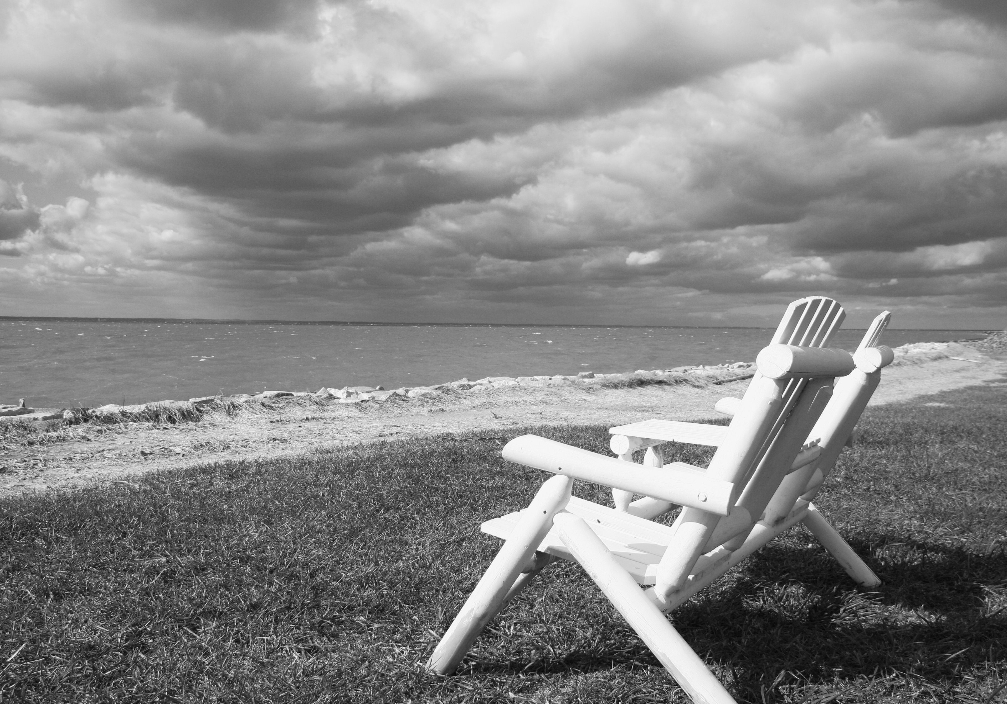
Above: Black Walnut Point – at the tip of the Island.

ABOVE: A great heron fishing, a common sight.

ABOVE: The dock at the end of my street, the day before “Sandy” arrived. My first day on the island!

ABOVE: Fog over Blackwater Marsh, a National Wildlife Sanctuary, about an hour’s drive from the island.

ABOVE: River Otters at Pickering Creek – a decent place to hike and only 25 miles away! 🙂

ABOVE: Living across the street from a working marina – always something interesting going on.

ABOVE: Where Pebbles and Bam Bam spent most of their winter days.

ABOVE: Hunting for sea glass became a pleasant diversion.

ABOVE: My last few weeks here I enjoyed the company of nearby Ospreys.

ABOVE: A board walk in Blackwater Marsh, and an appropriate symbol for the journey of my life.
The Ghost of Churches Past
Old buildings ( especially interesting are churches) intrigue me, as I know they do many people and I have driven past these ruins several times on the way to one of my favorite hiking spots here along the Eastern Shore of Maryland. On this occasion, I was travelling with a friend who also enjoys photography as a hobby, and as soon as she saw these ruins, she had the same reaction I did: “We have GOT to photograph” this!
And so with an ally by my side (all the better to ignore the really old “No Trespassing Sign” my dear), we spent a few minutes photographing the ruins of this old church.
I would have loved to have had blue skies overhead as a way to contrast the bright green ivy and ground covers that were overtaking these walls; but grey skies were dominant, so I settled for black and white medium.

The first picture (above) gives an overview of the site. The rest are a few interpretations of views I found interesting.


Progress Report
Those of you who routinely follow my blog may remember that I moved to the shores of the Chesapeake Bay in Maryland to have a serious go at writing. My intent was to write a book of essays about loss and my subsequent journey of reconnecting with life after suffering a profound loss. I’m pleased to report that I have completed a first draft!!
I set of goal of having a first draft completed by February 23rd, which is the date of a writer’s conference I will be attending in nearby Easton. Mission accomplished!! I never envisioned this being a lengthy book and the finished product looks as though it will be 140 – 150 pages.
In addition, after some coaxing from numerous friends, I decided to compile a book of photographs from my “Year in Acadia”, and will be making that available through a variety of channels. My goal is to have that projected completed by mid-April.
Below are a couple of pictures of my work space and also of “Pebbles”, one of my muses. 🙂


The Good, the Bad, and the Ugly
Sometimes nature just doesn’t cooperate. Yesterday, I got up early to check out the sunrise (which is now around 6:45 a.m.). My destination was Sand Beach with the express goal of shooting the morning glow of the “Beehive” (a large slab of steep granite) and it’s reflection in the pool that fills the marsh behind the dunes of Sand Beach.
The clouds were just beginning to roll in along with some fog as I drove along the road that enters the park. However, I was pretty confident that complete cloud cover would hold off for another hour or two.
I was right about the clouds. But much to my dismay when I arrived at my location, I discovered that either the tide had carried some nasty looking stuff into the marsh, or stream runoff had carried said nasty stuff. It looked as though someone’s washing machine had run amok. I don’t know that I’ve ever seen this phenomena to this degree at this location.
And then when the sun came up and hit the Beehive and the trees with their fall colors I had some the best photography light I’ve seen since I came to Maine!! I could have cried. So here it is; the good, the bad, and ugly from yesterday’s shoot.

I tried putting more marsh grass and less water in the shot, but then I lost the lovely fog bank hanging over Champlain mountain.

Maybe putting some distance between myself and the “icky” water will help.

When all else fails, try black and white mode!

Sunrise/Sunset
This week I’ve had some friends from Pennsylvania visiting the area for the first time. It has been great fun sharing Acadia and Mount Desert Island with “newbies”. In addition, they are both photography buffs (in fact it has become their second “career”), so we had cameras firing in all directions.
One of my friends wanted to shoot the sunrise in along Ocean Drive the first day after they arrived. Fortunately the sun is rising later here this time of year (not 4:45 a.m. as it does in June), but it was still an early wake up call with the alarm clock.


Of course cruise ship “season” is in full swing now, and this approaching ship is typical of their schedule – in at sunrise, out by five p.m..

Of course another favorite activity for folks visiting Acadia is to catch either a sunrise or a sunset from the summit of Cadillac Mountain. Since we had already done sunrise, it was going to have to be sunset for our trip to Cadillac. So off, we went, all three of us with our warm jackets and camera gear.

ABOVE: The crowd begins to vie for the best spots. Luckily, no fights broke out. 🙂
BELOW: The day ends

It dawned on me (no pun intended), as I was heading back to the car that I this was the first time I could remember consciously making an effort to see both the sunrise and the sunset on the same day. A nice item to “check off” one’s bucket list.
Sharing the Rocks
As this crisp fall weather arrives with it’s beautiful light; lovers of photography are out and about with varying levels of equipment. We know that this time of year is one of the best for getting great shots full of dramatic light and colors (not to mention black and white).
On this day (with it’s glorious sunset), I turned to look down the rocks at a fellow photographer. The spray from the high surf was creating a consistent mist, the sun had just broken through the clouds, and a seagull landed. I thought “quick, this could be good!”, and snapped the photo. When I got home and downloaded my photos, I was so excited to see the golden glow that infused this photograph. That’s all mother nature’s light – no filter or post production on this one!

Weeds or Wildflowers?
This time of year brings all sorts of floral “surprises” growing along the roadsides, in the meadows, and in the woods. What distinguishes a “weed” from a “wildflower”. I always thought that if it showed up in MY garden it was weed, if it was in someone else’s garden it must be a wildflower. Also, if it was in an area that I was unfamiliar with, SURELY it was a wildflower.
So in my first spring in Maine, I am enjoying the “wildflowers” along the way. And also, the deer! As I was hiking up the hill on “Kebo Street”, I passed this deer meandering through someone’s yard. I think she was attempting to disguise herself as a yard ornament!

And now, back to the wildflowers!


How sweet are these little flowers in the pic below? What I found most interesting was that they are some type of water or bog plant as they were growing profusely in the drainage ditch along the road. Apparently, they open pink and turn blue as they mature!

A Tale of Two Seasons
I thought it would be fun to share with you two photographs from the same location. The first one was taken in the beginning of January, the second the last day of April.


The Final Two…………bridges, that is.
I am happy to report that I have finally seen ALL 17 of Mr. Rockefeller’s bridges, and hiked all but 8 miles (out of 57 miles) of the carriage road system.
These last two bridges are located on what is commonly known as the Jordan Pond/Sargent Mountain carriage road. Reaching them is a steady two + mile gradual uphill hike, but the payoff is worth it. Both bridges are lovely, and the Deer Brook Bridge is especially stunning in its design and setting. The mist and fog on this day made for an “otherworldly” setting in which to observe them.


Deer Brook was running especially fast and high from the rain we received on Monday, and it made for beautiful scenery.

The two bridges were built within a year of one another, with Deer Brook Bridge being built in 1925 and Chasm Brook bridge in 1926. The date stone on the Deer Brook Bridge was unique, the only one I’ve seen (or noticed) that is round. It’s a little tough to read in this photo, but you get the idea.

After being completely charmed by the bridge and waterfall at Deer Brook, I hiked on to Chasm Brook. Much less grand in stature, it is charming in a much more humble way. What really impressed me about this bridge is how it seems to spring out of the rock face, which you can see in the 2nd photo, below.


The carriage roads and the bridges that grace them are one of the many things that make Acadia unique among America’s national parks. I know I will continue to visit and enjoy the wonderful legacy of Mr. Rockefeller and his roads.
After the Storm
After a day of torrential rain and gusty (some very gusty) wind (or as we like to call it here on the island – breezes), it was time to get back out on the trails and get in some hiking miles.
My destination were the last two bridges in the carriage road system, a 5.5 – 6 miles roundtrip hike that would carry me above Jordan Pond. I’ll cover the bridges in another post, because they were both beautiful, but I have to confess that the fog and water were worthy of a post in their own right.

Even though the sun was trying to make an appearance when I left Bar Harbor, just a few miles inland, the fog was winning out, giving the carriage road a “Sleepy Hollow” kind of feel. As I headed away from Jordan Pond I heard the sound of loons echoing across the water. It definitely set the mood for the morning.

This particular stretch of carriage road winds pretty steeply up the mountain, hugging the cliffs above Jordan Pond. Of course the pond was completely obscured from view on the way up the mountain, but by the time I headed back down; I could make out the water and the “Bubbles” mountains. I love the way the fog was hugging the mountaintops, giving me that delicious feeling of being alone and cocooned by nature.

At both bridges along my route, I was treated to rushing waterfall, swollen by yesterday’s rains. Pictured below is Deer Brook Falls. There is a trail that follows this stream back to Jordan Pond. At one point the trail crosses over the stream. Today, that crossing was impossible as the stepping-stones were underwater. But all that water sure made for great picture-taking!


Another mile and a half of hiking and I came to second waterfall along Chasm Brook. By now, the fog was beginning to lift out and I could get a sense of what the view was like as I neared the crest of the mountain. For those readers familiar with Acadia National Park (or those with a map of the park), the body of water in the distance is Aunt Betty’s Pond.

And below is a picture of the Chasm Brook Waterfall. Not having hiked this particular portion of the carriage roads, I was hoping to see at least one waterfall, and I was treated to two!

